5 days ago
482
5 days ago
482
Published June 9, 2026 9:32 PM CDT
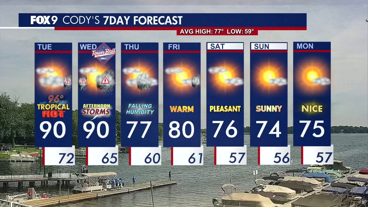
MINNEAPOLIS (FOX 9) - We had a hot and steamy Tuesday, which is leading up to the possibility of strong to severe thunderstorms for parts of Minnesota overnight into Wednesday morning.
Severe Thunderstorm Watch until 4 a.m.
What we know:
The National Weather Service issued a Severe Thunderstorm Watch for parts of Minnesota, North Dakota and South Dakota until 4 a.m. Wednesday. The areas potentially impacted include far western and northwestern Minnesota.
The watch goes as far south as near Marshall and extends to Montevideo, Morris, Alexandria, Wadena, Detroit Lakes, Fargo-Moorhead and as far north as Roseau.
The watch does not currently include any counties in or near the Twin Cities metro.
Storm chances late Tuesday night
The backstory:
Thunderstorms are expected to develop in the Dakotas this evening and move into western Minnesota around midnight before spreading east overnight. The greatest storm chances run from 10 p.m. to 4 a.m. in western and central Minnesota and from 1 a.m. to 5 a.m. in the Twin Cities metro.
Western and central Minnesota are under a level 2 slight risk and level 3 enhanced risk of severe weather, while the Twin Cities metro remains under a level 1 and level 2 risk.
The primary threat is damaging wind gusts over 60 mph. Large hail ranging from 0.50 to 1.50 inches in diameter is also possible, along with localized heavy downpours. An extremely isolated quick spin-up tornado cannot be ruled out.
What we don't know:
Storms are expected to weaken as they move east into a more stable environment, but they may still produce strong winds and heavy rain overnight. How these storms evolve could also have a significant impact on the potential for another round of storms Wednesday afternoon and evening.
Extended Minnesota weather forecast
What's next:
Wednesday stays warm and humid, with patchy sunshine and additional storm chances developing through the afternoon and evening.
The Twin Cities metro, much of Wisconsin, and parts of Iowa and Illinois are under a level 3 enhanced risk for severe weather. Damaging winds, large hail, and isolated tornadoes could be possible.
WeatherMinnesotaSevere Weather